EN
Expertise

Georegistry & Microplanning Tools

Robust geospatial data, integrated planning tools, and adaptive solutions for better health system management.

what we do

Georegistries and comprehensive geospatial data that serve as critical foundations for resource allocation and planning.

By providing accurate, up-to-date, and precise geospatial data, our platforms enable countries to improve microplanning, optimize resource allocation, strengthen surveillance and monitoring, and enhance coordination across programs and partners through greater systems interoperability.

Georegistries

Master Facility Lists (MFL)

Targeted microplanning

Challenge

Key Challenges in Georegistries and Microplanning

Countries often face systemic barriers when building or maintaining georegistries and MFLs, leading to inefficiencies and misaligned interventions.

Data fragmentation

Facility lists and geospatial data scattered across ministries, NGOs, and donors, without a unified standard.

Lack of standards

Inconsistent definitions and lack of harmonization on typology and classification of health service delivery sites.

Low data quality

Outdated, inaccurate, or missing location and service information.

Weak interoperability

Low levels of interoperability between health information systems, due to a lack of comprehensive common georegistries.

Limited data use

Geospatial data often exists but is underutilized for surveillance, monitoring, microplanning and wider decision-making.

Solutions

Our solution to optimize georegistries & microplanning

Bluesquare delivers comprehensive digital solutions to design, implement, and sustain georegistries and geospatial data for improved planning, resource allocation, surveillance, and monitoring.

1

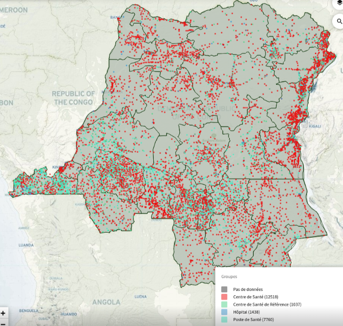
Designing Georegistries

We help governments assess needs, design data models, and create robust, country-specific frameworks for georegistries and master facility lists.

  • Needs assessment & gap analysis to define requirements based on existing data and partners
  • Comprehensive data models integrating facility attributes and geospatial components
  • Solid georegistry systems architecture and digital tools
  • Tailored structures & attributes aligned with national standards and global best practices
  • Health information systems interoperability through shared georegistries
  • Capacity building & training for national teams
2

Implementation & Integration Support

We provide tools and methodologies to collect, validate, and integrate facility and location data, ensuring interoperability and long-term usability.

  • Geocoding and georeferencing of facilities for accurate mapping, and collecting of data attributes using IASO
  • Training and support for data entry, validation, and quality assurance
  • Seamless integration with DHIS2, LMIS, and other national data systems
  • Interactive health facility maps and advanced visualizations via Superset, DHIS2, Power BI, Tableau, or other BI tools.
  • Accessibility modeling and geospatial analytics to support planning (e.g. coverage gaps, resource allocation)
3

Maintenance & Support Services

We ensure sustainability by setting up robust processes for regular updates, quality control, and technical assistance.

  • Routine update procedures to keep Master Facility Lists (MFL) current and reliable
  • Quality assurance protocols for long-term data accuracy
  • Ongoing technical support for troubleshooting and user engagement
  • Data security & privacy with strong governance and access controls
  • Monitoring & reporting tools to track system performance
  • Technical training & capacity building to maintain national expertise
Collaboration

Who we support

Public authorities

Ministries of Health, Social and Environmental Programmes, etc.

International organizations

World Health organization, UN agencies, etc.

Non-Governmental Organizations (NGOs)

International and in-country organizations

Ce site est enregistré sur wpml.org en tant que site de développement. Passez à un site de production en utilisant la clé remove this banner.